

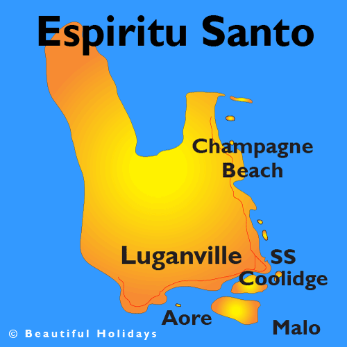
Map of Espiritu Santo- Vanuatu
Espiritu Santo is the largest island in the nation of Vanuatu, with an area of 3,955.5 km2 (1,527.2 sq mi) and a population of around 40,000 according to the 2009 census.
It belongs to the archipelago of the New Hebrides in the Pacific region of Melanesia. It is in the Sanma Province of Vanuatu. The town of Luganville, on Espiritu Santo's southeast coast, is Vanuatu's second-largest settlement and the provincial capital. Roads run north and west from Luganville but most of the island is far from the limited road network.
Vanuatu's highest peak is the 1879 metre (6165 foot) Mount Tabwemasana in west-central Espiritu Santo.
In 1998, Santo hosted the Melanesia Cup.
The Ni-Vanuatu Vatu is the currency of Vanuatu. Our currency rankings show that the most popular Vanuatu Vatu exchange rate is the AUD to VUV rate. The currency code for Vatu is VUV, and the currency symbol is VT.
History
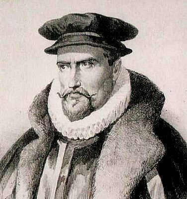
A Spanish expedition led by Portuguese explorer Pedro Fernandes de Queirós, established a settlement in 1606 at Big Bay on the north side of the island. Espiritu Santo takes its name from Queirós, who named the entire island group La Austrialia del Espíritu Santo in acknowledgment of the Spanish king's descent from the royal House of Austria, and believing he had arrived in the Great Southern Continent, Terra Australis. During the time of the British–French Condominium, Hog Harbour, on the northeast coast, was the site of the British district administration, while Segond, near Luganville was the French district administration.
During World War II, particularly after the Japanese attack on Pearl Harbor, the island was used by Allied forces as a military supply and support base, naval harbor, and airfield. In highly fictionalized form, it is the locale of James Michener's Tales of the South Pacific and the subsequent Rodgers and Hammerstein musical, South Pacific. The presence of the Allies later contributed to the island's diving tourism, as the United States dumped most of their equipment and refuse at what is now known as 'Million Dollar Point'. Another wreck off Espiritu Santo, the SS President Coolidge, is also a popular diving spot. The SS President Coolidge was a converted luxury liner that hit a mine during the war.
Between May and August 1980 the island was the site of a rebellion during the transfer of power over the colonial New Hebrides from the condominium to independent Vanuatu. Jimmy Stevens' Nagriamel movement, in alliance with private French interests and backed by the Phoenix Foundation and American libertarians hoping to establish a tax-free haven, declared the island of Espiritu Santo independent of the new government. A Republic of Vemerana was proclaimed on May 28. France recognized the independence on June 3. On June 5 the tribal chiefs of Santo named the French Ambassador Philippe Allonneau "King of Vemerana", Jimmy Stevens became Prime Minister. Luganville is renamed Allonneaupolis. But negotiations with Port-Vila failed and from July 27 to August 18, British Royal Marines and a unit of the French Garde Mobile were deployed to the Vanuatu's capital island but did not invade Espiritu Santo as the soon-to-be government had hoped. The troops were recalled shortly before independence. Following independence, Vanuatu, now governed by Father Walter Lini, requested assistance from Papua New Guinea, whose forces invaded and conquered Espiritu Santo.
Culture
Santo, with many wrecks and reefs to be explored, is a very popular tourist destination for divers. Champagne Beach draws tourists with its white sand and clear waters. The "Western Side" of the island contains many caves which may be explored, and cruise ships often stop in at Luganville.
The local people make their living by supporting the tourist trade, by cash-crop farming, mostly copra but some cacao and kava as well as peanuts, or by subsistence farming and fishing.
Most Santo people are Christians. The largest church groups on the island are the Presbyterian Church of Vanuatu, the Roman Catholic Church and the Church of Melanesia (Anglican). Also active are the Apostolic Church, the Church of Christ, the Seventh-day Adventist Church, and others. However, in many villages, particularly in Big Bay and South Santo, the people are "heathen", a term that in Vanuatu has no pejorative connotation — it simply denotes someone who has not embraced Christianity. Customary beliefs of a more modern sort are found among followers of the Nagriamel movement based in Fanafo.
For almost all Santo's people custom plays a large part in their lives, regardless of their religion. The chief system continues strongly in most areas.
The people of Santo face some health problems, especially malaria, and tuberculosis . Although there is a hospital, most locals consult either their own witch doctor or medical clinics set up by western missionaries. Kava is the popular drug of the island, although alcohol is becoming more prevalent. With the rising number of adults using alcohol, there is a rising crime rate, especially involving violence toward women, and tribal warfare.
Economy and infrastructure
Luganville is the only true town on the island; the rest of the island is dotted with small villages. From Luganville, three ‘main’ roads emerge. Main Street leaves the town to the west and winds along the south coast of the island for about 40 km ending at the village of Tasiriki on the southwest coast. Canal Road runs along the south and east coast of the island, north through Hog Harbor and Golden Beach, ending at Port Olry. Big Bay Highway splits off from Canal Road near Turtle Bay on the east coast, runs generally west to the mountains, and then leads north to Big Bay. The airport is about five km east from the center of Luganville. Numerous rivers run to the coastline from the mountains of the island. The Sarakata River is one of the largest and runs through Luganville.
Many people on Espiritu Santo still rely on subsistence farming for their food. The villages on the island are mostly self-sufficient with their own vegetable gardens, chickens and pigs. Taro and yam are commonly grown in these gardens, and are mainstays of the local diet.
Santo is home to a number of cattle farms (including the famous Belmol Cattle Project, originally established by French settlers) and exports much of its beef to Japan, Australia and other Pacific Island countries.
Besides beef, tin fish and rice, bought in town, Santo has many foods that locals take for granted and that tourists enjoy as delicacies. Among these are sweet pineapples, mangoes, island cabbage, flying fox and coconut crab, as well as local nuts such as natapoa and the sweet fleshy-fruit nouse. There is a market in Luganville where local food such as manioc, taro, yam, cabbage and other freshly grown island staples are sold. Several small supermarkets such as LCM, Unity Shell and Au bon Marche, sell groceries and many packaged goods.
Biodiversity
The island of Espiritu Santo is home to all of Vanuatu's endemic birds, including the Santo mountain starling, a species restricted entirely to Santo. Two protected areas have been established to safeguard the island's biodiversity; the Loru Conservation Area on the east coast and the Vatthe Conservation area near Big Bay in the north.
The Loru Rainforest Protected Area is situated in the lowland rainforests of Santo. Established in 1993 by Chief Caleb Ser, the 220 hectare reserve supports a rich variety of Vanuatu's bird, bat and plant life as well as a diverse range of marine species in the two-kilometre stretch of fringing reef.
Activities
 Champagne Beach is a popular beach located on the island of Espiritu Santo in Vanuatu. It is famous for its beautiful white sandy beaches, one of the best in the South Pacific. |
 Aore Island is an island in Sanma Province, Vanuatu. It is located opposite Luganville on Espiritu Santo and has an area of 58 km2. Aore Island has diving and fishing. |
 The Nanda Blue Hole (also known as Jackie's Blue Hole) is often referred to by visitors as the most beautiful blue hole in Vanuatu. Address: East Coast Road, Natawa, Sanma... |
 The bungalows of Lonnoc Beach are nestled on the beautiful shores of Lonnoc, just around the corner from another popular destination, Champagne Beach. |
 Matevulu Blue Hole- One of the largest blue holes on Espiritu Santo and it is indeed deep blue in color. Blue holes are a natural phenomenon and are common to the island... |
 Located on the isolated west coast of Espiritu Santo, Mount Tabwemasana is not only the highest peak in Vanuatu, but also one of the highest mountains in the Pacific. |
Accommodation
|
 |
||
 |


Flights
|
|||||


Car Rental
 |
||